Loading...
Map lookup
Reference lookup
Plot sheet result
Select a plot sheet below to open them in the Plot Sheet Viewer:
User guide
Introduction
Planning decisions and history searches post 1988 can be carried out using our Public Access system but historic planning decisions, dating from 1948 to 1988, are now available using our online portal. In addition, our historic plotting sheets are also available to view online and allows a customer to carry out searches back to 1948.
The two elements are independent of each other, meaning if a customer only wishes to view historic decision notices, they can do that without needing to view the plotting sheets.
Using the historical planning plotting sheets
Finding the address
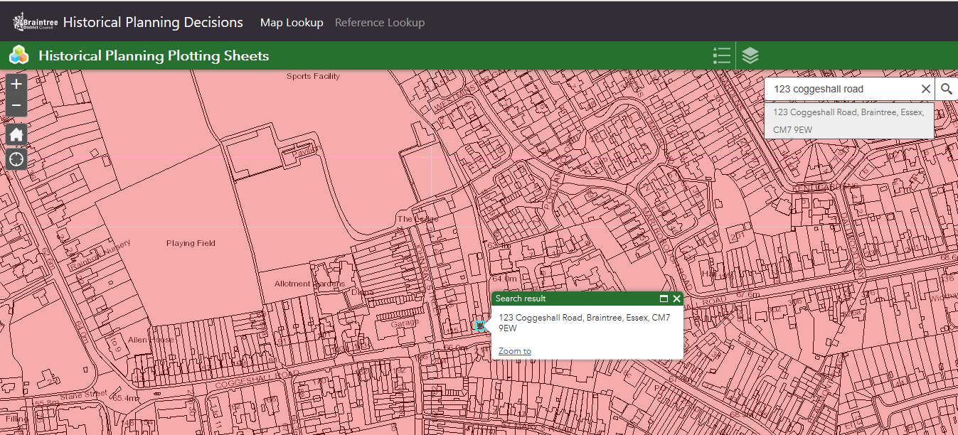
The easiest way to view the plotting sheets is to use the "Address search" box. Type the address as required. The map will then zoom to this address.
If you don't have a specific address, you can use the + / - icons to zoom in and then move the map to your required area. Click the

Accessing Plotting Sheets
When you have found the area for which you wish to view the historic plotting sheets for, click on the map. It will display your search results similar to the below images. Note the search shows (1 of 2). The first result usually shows the "Post 1974 Plotting Sheets".
To view the second result, click on the

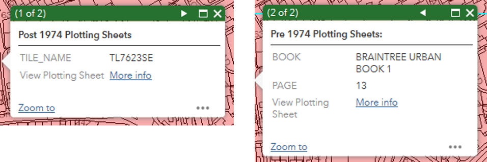
To view the plotting sheets from either result, click on the "More info" link. This will open a new window so do bear in mind that if you want to view the plotting sheets from the other result, you'll need to return to this window to do so.
Viewing the plotting sheets
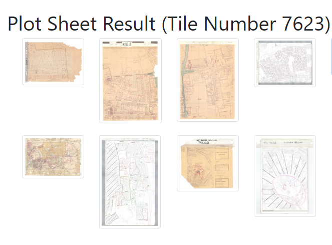
The plotting sheets will display as thumbnails, an example is shown below. Some areas of our district have multiple plotting sheets that may show particular areas separately to the main sheet, for example, industrial estates or newer housing estates. You will likely need to check each sheet to ensure you have covered everything.
Click on one of the thumbnails and the window will change to a viewer style window:
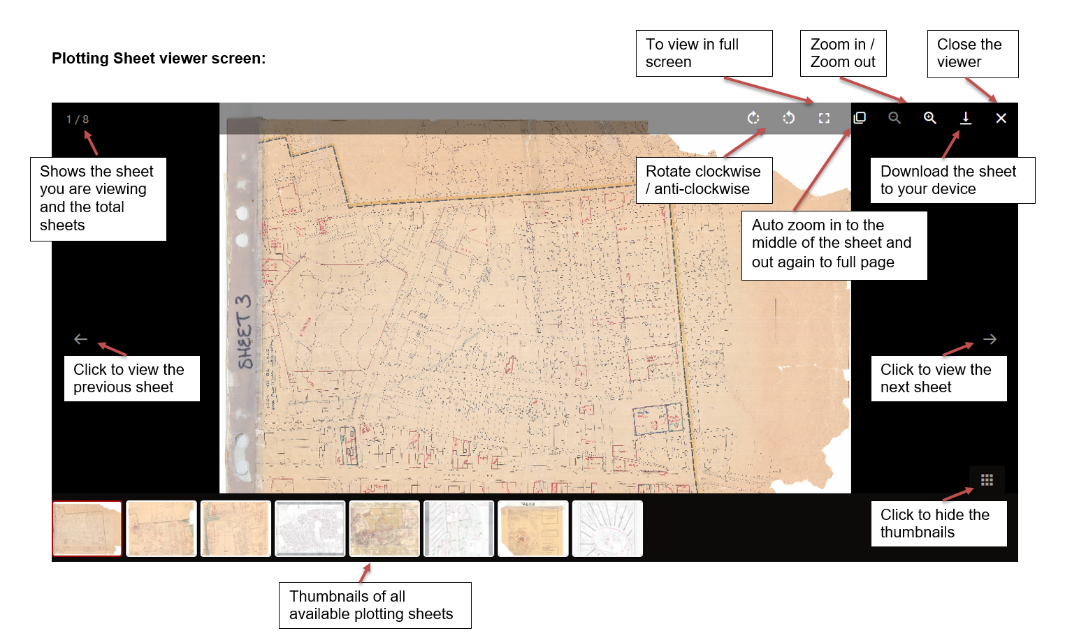
Click on the zoom in or auto-zoom buttons and then move the sheet around until you find the area you need
Rotate the sheet if required
Planning applications will show as a red polygon with a reference number next to it. Make a note of these reference numbers to view later
Click on the thumbnails at the bottom or the forward and back arrows to the sides to view more sheets where applicable
Don't forget to repeat the above for viewing the pre-1974 plotting sheets too (if you need to)
When you are ready to view the historic decision notices, either click on the X to close the viewer window, or keep this window open and click on the tab to view your previous window (Map Lookup)

Viewing the decision notices
To view the historic decision notices (1948 to 1988), click on the Reference Lookup button at the top of the website:

Enter the reference number as the help text suggests, e.g. 76/21 then click on Find Decision
Sometimes the results will show multiple entries:
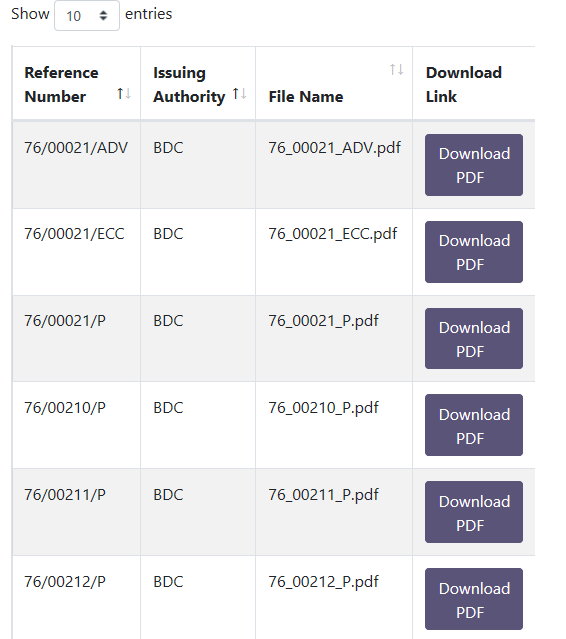
Scroll up and down the list to find the relevant reference number.
Click Download PDF on the relevant entry to open and / or save (these options should appear at the bottom of your screen in Google Chrome or Microsoft Edge)
Accessibility statement
This accessibility statement applies to Historical Planning Decisions (https://historicalplanning.braintree.gov.uk).
Braintree District Council run this website. We want as many people as possible to be able to use this website. For example, that means you should be able to:
- change colours, contrast levels and fonts
- zoom in up to 300% without the text spilling off the screen
- only use a keyboard to navigate most of our website
- navigate most of the website using speech recognition software
- listen to most of the website using a screen reader. This includes the most recent versions of JAWS, NVDA and VoiceOver
AbilityNet has advice on making your device easier to use if you have a disability.
How accessible our website is
We have designed and built our website to meet the Web Content Access guidelines 2.1 AA standard (WCAG).
We have reviewed the content on our website to make sure it is as clear and simple as possible (WCAG 3.1.5).
We will continue to review and update our content to make sure that it is:
- in plain English
- jargon free
- has a year nine reading level
The colour contrast (WCAG 1.4.1) of our site meets AA standard for:
- buttons
- images
Feedback and contact information
You should contact us if you need information on our website in different formats such as:
- accessible PDF
- large print
- audio recording
- braille
So that we give you a quick response, tell us:
- the web address (URL) of the content
- your name and email address
- the format you need the information in
We will reply to your enquiry within one working day.
Reporting accessibility problems with this website
We're always looking to improve the accessibility of our website.
You should contact us if you find any issues we haven't listed on this page or think we're not meeting the standard.
Enforcement procedure
If you contact us about an issue and you're not happy with our response, contact the Equality Advisory and Support Service (EASS).
The Equality and Human Rights Commission (EHRC) enforces the Public Sector Bodies (Websites and Mobile Applications) (No. 2) Accessibility Regulations 2018.
Contacting us by phone or visiting us in person
Our offices are open Monday to Friday between 9:00 am and 5:00 pm.
By phone: 01376 552525
In person: You can visit us at Causeway House during our opening hours. We have audio induction loops at our service desk.
Technical information about this website's accessibility
Braintree District Council is committed to making our website accessible, in accordance with the Public Sector Bodies (Websites and Mobile Applications) (No. 2) Accessibility Regulations 2018.
Our website is fully compliant with the WCAG 2.1 AA standard.
Content that's not within the scope of the accessibility regulations
PDFs and other documents published before 23rd September 2018
We do not have to make PDFs or other documents published before 23rd September 2018 accessible, if:
- they're not essential to providing our services
- a member of the public has published them (for example planning documents)
- another organisation has published them (for example another local authority)
PDFs and other documents published after 23rd September 2018
We do not have to make PDFs or other documents published after 23rd September 2018 accessible, if:
- a member of the public has published them (for example planning documents)
- another organisation has published them (for example another local authority)
Live video
We are not planning to add captions to live video streams. Live video is exempt from meeting the accessibility regulations.
Interactive maps
Interactive maps are exempt from meeting the accessibility regulations.
Content that isn't in plain English
When we built our website, we used a detailed guide to write our content to a year nine reading level.
All new pages and documents we publish on our site will have a year nine reading level or lower.
We will only write pages and documents above this reading level if there is a legal need to do so.
Page not found
The page or link you're trying to get to doesn't exist.